Norsk

Skåranipa from Skår in Syvde, route 43a

Vanylven

The trail at a glance

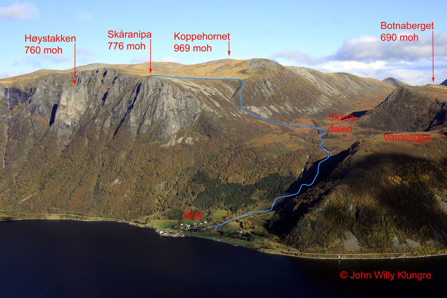
Skåranipa rises almost vertically up from just outside of the village of Skår in Syvde. If you want to experience the amazing mountain area between Skår and Syvdsneset, this trail from Skår up to Skåranipa would be the fastest option. It is also possible to walk through more difficult terrain up from Syvdsneset or choose much easier terrain, but cover a much longer distance with the start from Årskogdalen in Rovde: 
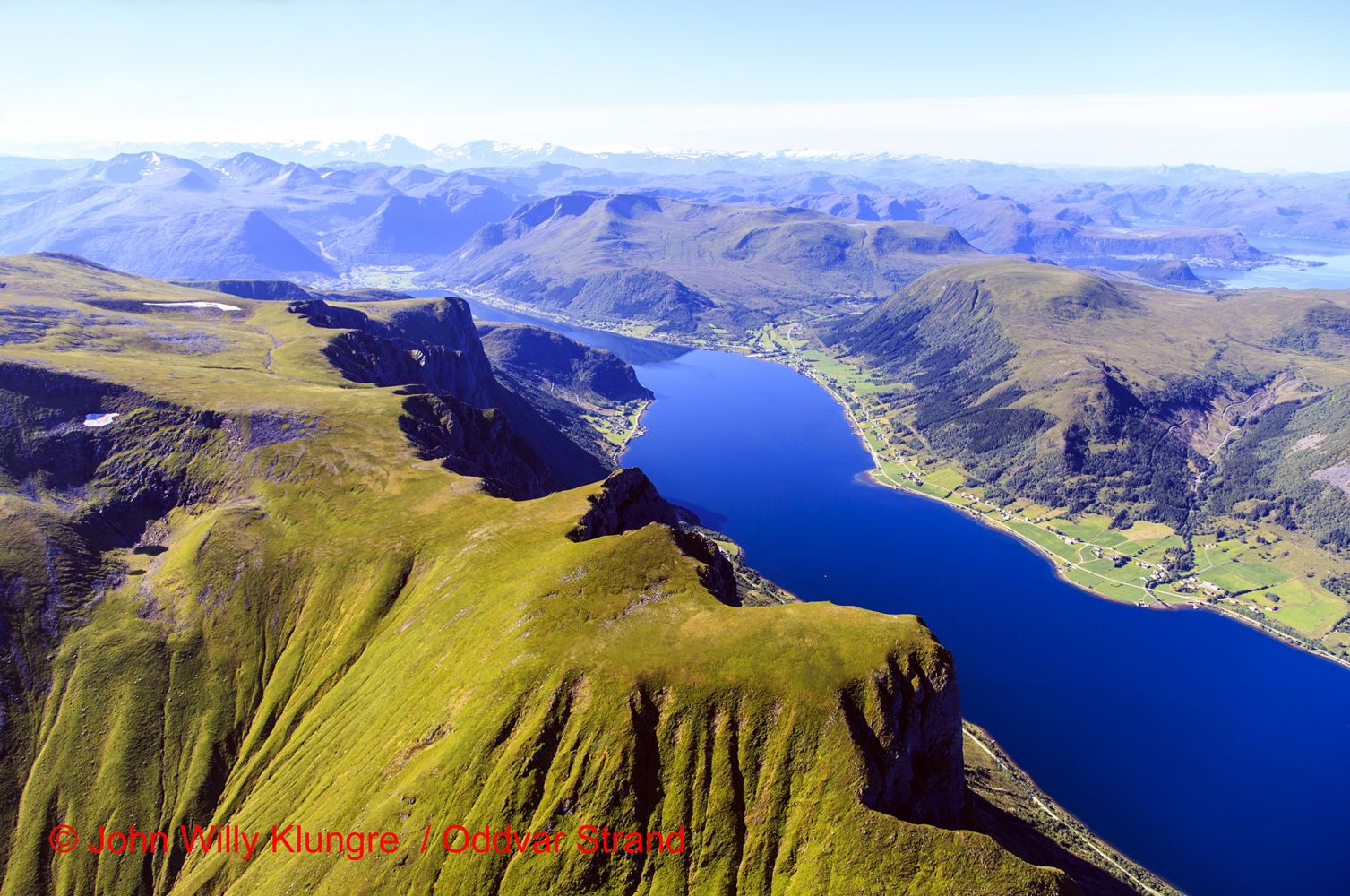
http://mrfylke.no/Morotur/Turar/Rovde-Breiteigsfjella-rute-25-43 The Syvde Sports Association set up a trail post at the top of Skåranipa, and for those of you who want to register in as many trail journals as possible, you can also visit Ulvenakken on the same day. From Skåranipa, you can enjoy a fantastic view towards the ocean and the islands in the west as well as the view towards the area of Sande, Herøy, and Ulstein in the north. To enhance the experience of this hike even further, take a loop trail around the plateau in the direction of Syvdsneset and enjoy the fantastic view of the alpine landscape. The contrast between these wild mountain formations and the idyllic landscape on the plateau is an experience in its own right.On your way back from this loop trail with the start at Skåranipa, you can also see the northeastern side of the plateau that stretches towards Rovde. Here, you will see some spectacular cirques and the steep mountainside of Blåhamrane. In good weather you will also see Mount Gamlemsveten in Haram Municipality and the Sunnmørsalpane mountain range in the east.

Route description

The first section of the hike stretches from the car park by the power station in Skår up to the end of the road in the Skåradalen Valley. This road is steep and fairly difficult, but it will take you up to Skåradalen fast. Walk further into the valley and cross the river that flows through the valley just above the place where the Fossane River crosses it. From here, you can quickly and relatively easily get to Ulvenakken (route 43b) where you will find the Syvde Sports Association’s trail post. You can usually cross the river without getting wet. Continue walking over a relatively dry marshy area until you reach a birch forest. At the end of the birch forest, you will come up to the lower part of the area that the Fossane River is believed to be named after. The section of the river from the plateau on top down to this area is a long continuous “waterfall” (Nor. “Foss”), which is not completely vertical, but still impressive. The river course here is really spectacular. It has a smooth surface, and the river flows through an almost perfectly V-shaped valley which is on the border of being a river canyon. From Fossane, walk steeply up the Nyklane ridge. This is the steepest section of the trail and the reason why is it graded red. It will gradually become less steep. You will be amazed by the contrast between the steep mountain ridge and the almost entirely flat grassy fields with clearly defined sheep tracks. From here, you will quickly get to Skåranipa through gentle terrain.

Access and parking

The place where you need to turn off the national road in Skår is signposted. After that turn, take the turn to the right at the first junction and drive over the bridge. Turn left just after the bridge and park your car next to the power station. The starting point of the trail is signposted, and the route from the end of the road in Skåradalen up to Skåranipa is marked with blue sticks and blue paint on trees and similar objects. There is a parking area near the power station in Skår. You will also find information boards there with descriptions of hiking trails in the area.
Hiking route
Red
Distance
3,93 km one way
Elevation
755 m
Duration
3 t. 55 min.
Sesong
Summer, Autumn
Highest Point
769 masl
Signage
Both signed and marked

Map route

Surface type Distance
Grus 3
Sti 4

Map

Hiking map: På tur i Vanylven (Eng. Hiking in Vanylven) – can be purchased at local shops and petrol stations in Vanylven Municipality.
Driving directions

API endpoints

Route data GeoJSON