Alternative 1: This is a looped trail that follows a clear path through grazing land, a tractor road, a gravel and an asphalt road. If you start from the centre, you will pass Grytesteinen half way through the trail.Alternative 2: This is a short fitness trail where you will primarily walk through a nice cultural landscape. It is convenient to take a break from walking near the trail postbox. From here, you have a great view down to the ferries gliding across the fjord.
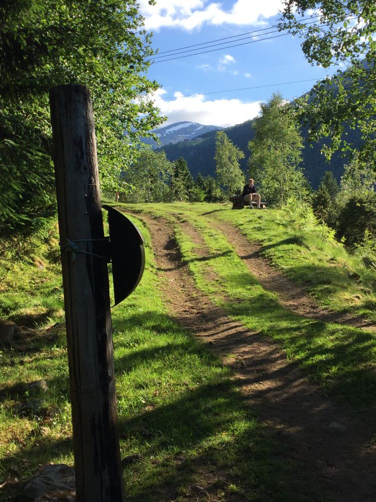
Alternative 1: Looped trail. Park your car at the ferry terminal in Eidsdal. Walk in the direction of Norddal for about 200 metres. Right after the bridge, turn off to the right and follow the waymarked path towards Rongane. The first hundred metres are steep, then the terrain flattens out and you walk into a grazing area for sheep. (You can also see horses grazing on the field here.) This is where you walk into a nice cultural landscape. Stop number one is Grytesteinen. To learn more about the area, take a look through the book that you will find in the trail postbox here. Continue following the trail as it climbs up a steep hillside until you reach a tractor road. The ascent eases here. Follow the tractor road until you come to the trail postbox in Rongane. From here, you can watch the ferries go across the fjord between Eidsdal and Linge. You can A): walk down to the right (west) from the road, about 25 metres after the trail postbox. Please see the description of Alternative 2. Or B): Walk further following the tractor road. Watch out for rams on the pasture. Follow the road further to Hjelle. From here, you can either walk along the main road down to the ferry terminal or go further up along the main road to Veiberg. Walk across the road after the bridge in Veiberg (main road). Turn right and walk over the residential building site until you come to an old forest road. The road is partly overgrown, but you will soon walk on a gravel road and then an asphalt road. Follow this road down to the ferry terminal. Under very bad weather conditions there may be an avalanche danger in the first part of the trail. The expected time for this trail alternative is about 1 hour and 45 minutes.Alternative 2: The trail starts from the car park next to the Eidsdal school building. The school is about 1 km away from the ferry terminal in the direction of Geiranger, on the western side of the national road. Walk back over the bridge, cross the main road, take the turn to the right and walk up the valley for 50 metres before you turn left where the walkway ends. Right after you pass the driveway to a residential building, turn off from the motor road onto the southeastern side of the road. Follow a narrow path for about 100 metres. As you walk through the gate, make sure to close it behind you, since there are animals grazing on the field. Follow the clear path through steeply ascending terrain. The path will soon take a turn to the left and then to the right. You will come to a plain where you will see a picturesque old barn. The path meanders further up through the deciduous forest. Once you are up on the tractor road, take the turn to the left and you will find the trail postbox after about 25 metres.Go back the same way as you went up. The expected time for the entire trail from the car park by the school building to Rongane is about 30 minutes.
The trail starts from the centre of Eidsdal. Park your car at the quay, behind the old village shop, or leave your car at the ferry terminal in Linge. In that case, use the car park next to the road. (The car park down at the quay is often full in summer.)
Alternative 1: Ferry terminal in Eidsdal.
Alternative 2: Eidsdal School, about 1 km from the ferry terminal in Eidsdal in the direction of Geiranger.
Duration
55 min.

Sesong
Spring, Summer, Autumn
Signage
Both signed and marked
| Surface type |
Distance |
| Asfalt |
1,1 |
| Sti |
1,1 |
To check bus departures from Ålesund to Valldal/Geiranger and ferry timetable Eidsdal – Linge, please go to
http://www.frammr.no or call 177.
Norddal tourist map 1:50 000
 Driving directions
 Route data
GeoJSON
Route data
GeoJSON